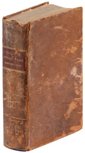
Title: The American Coast Pilot: Covering the Course and Distances Between the Principal Harbours, Capes and Headlands, from Passamaquoddy, through the Gulf of Florida... Together with the Courses and Distances from Cape Cod and Cape Ann to Georges' Banks...with the Latitudes and Longitudes of the Principal Harbours on the Coast, Together with a Tide Table. Author: Furlong, Lawrence Place: Newburyport Publisher: Edmund M. Blunt Date: 1800 Description: 251, +[5] ad pp. 8¾x5¼, full period tree calf, red morocco spine label. Third Edition. Third edition of the primary American navigational guide, all early editions of which are rare. Published without maps or plates, as was the first edition of 1796, the only copy of which to appear at auction in the recent past sold for $57,600 in 2007. Howes F421 Lot Amendments Condition: Spine a touch worn with a small repairs at head and heel, small hole in front flyleaf, lacking rear free endpaper; else very good or better. Item number: 196892
Title: The American Coast Pilot: Covering the Course and Distances Between the Principal Harbours, Capes and Headlands, from Passamaquoddy, through the Gulf of Florida... Together with the Courses and Distances from Cape Cod and Cape Ann to Georges' Banks...with the Latitudes and Longitudes of the Principal Harbours on the Coast, Together with a Tide Table. Author: Furlong, Lawrence Place: Newburyport Publisher: Edmund M. Blunt Date: 1800 Description: 251, +[5] ad pp. 8¾x5¼, full period tree calf, red morocco spine label. Third Edition. Third edition of the primary American navigational guide, all early editions of which are rare. Published without maps or plates, as was the first edition of 1796, the only copy of which to appear at auction in the recent past sold for $57,600 in 2007. Howes F421 Lot Amendments Condition: Spine a touch worn with a small repairs at head and heel, small hole in front flyleaf, lacking rear free endpaper; else very good or better. Item number: 196892


/621/1208621.jpg)


Try LotSearch and its premium features for 7 days - without any costs!
Be notified automatically about new items in upcoming auctions.
Create an alert