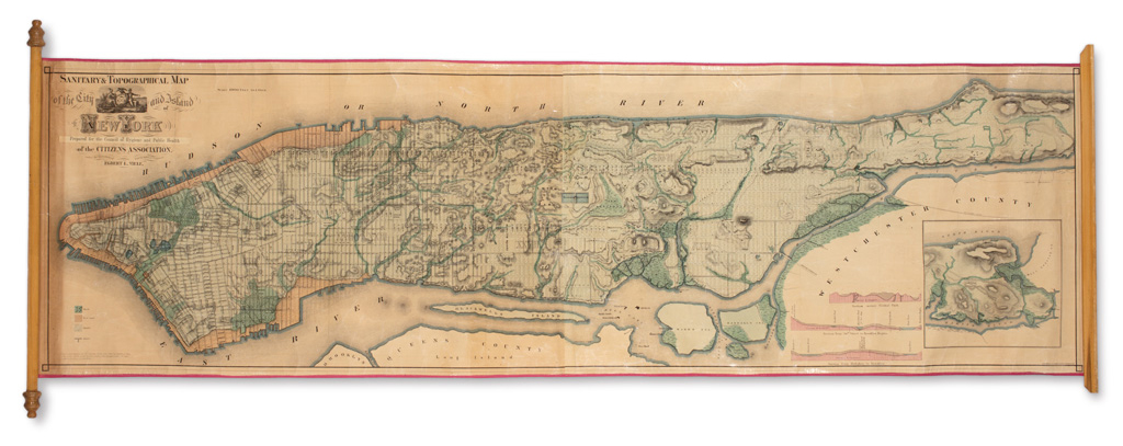
Title: Sanitary & Topographical Map of the City and Island of New York [in] Report of the Council of Hygiene and Public Health of the Citizens' Association of New York, Upon the Sanitary Condition of the City. Author: Viele, Egbert L. Place: New York Publisher: D. Appleton and Company Date: 1866 Description: cxliii, 360 pp. 53 full page, folding, or in-text maps, plans and illustrations (complete). (8vo) period dark green half morocco and marbled boards. First Edition. An important report on the sanitary conditions in New York City, includes the rare and iconic map of Manhattan by Viele, hand-colored, printed on two sheets joined together, approximately 45x176 cm. (17¾x69¾"). Viele's map is noteworthy for showing the original land and groundwater characteristics of the famously build-up city. These features include streams, ponds and wetlands, reservoirs and landfill, with location of piers, streets, aqueducts and sewers. Includes a color key and three ancillary map profiles: "Section across Central Park, Section from 50th Street to Brooklyn Heights, Section from Hoboken to Brooklyn." There are several variants of this map, all issued circa 1865, the present issue is on a heavier paper than the two other examples offered in our galleries in the recent past. Lot Amendments Condition: Light wear to binding; the Viele map has been removed from the binding and the two sheets professionally joined; near fine. Item number: 251985
Title: Sanitary & Topographical Map of the City and Island of New York [in] Report of the Council of Hygiene and Public Health of the Citizens' Association of New York, Upon the Sanitary Condition of the City. Author: Viele, Egbert L. Place: New York Publisher: D. Appleton and Company Date: 1866 Description: cxliii, 360 pp. 53 full page, folding, or in-text maps, plans and illustrations (complete). (8vo) period dark green half morocco and marbled boards. First Edition. An important report on the sanitary conditions in New York City, includes the rare and iconic map of Manhattan by Viele, hand-colored, printed on two sheets joined together, approximately 45x176 cm. (17¾x69¾"). Viele's map is noteworthy for showing the original land and groundwater characteristics of the famously build-up city. These features include streams, ponds and wetlands, reservoirs and landfill, with location of piers, streets, aqueducts and sewers. Includes a color key and three ancillary map profiles: "Section across Central Park, Section from 50th Street to Brooklyn Heights, Section from Hoboken to Brooklyn." There are several variants of this map, all issued circa 1865, the present issue is on a heavier paper than the two other examples offered in our galleries in the recent past. Lot Amendments Condition: Light wear to binding; the Viele map has been removed from the binding and the two sheets professionally joined; near fine. Item number: 251985


Testen Sie LotSearch und seine Premium-Features 7 Tage - ohne Kosten!
Lassen Sie sich automatisch über neue Objekte in kommenden Auktionen benachrichtigen.
Suchauftrag anlegen