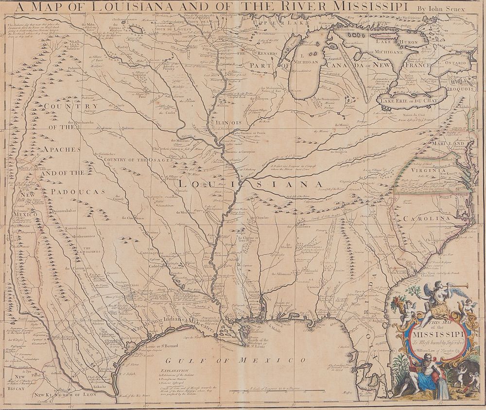
Senex, John. Map of Louisiana and of the River Mississipi [sic]. [England]. 1719. 19 x 22 in. inside neatlines. Early (possibly original) hand coloring. This Senex map is a direct plagiarism of De l'Isle's (Delisle) 1718 map of the same area ("Carte de la Louisiane et du Cours du Mississipi"). Delisle emphasized the French dominion of the Mississippi drainage and marginalized the British colonies on the east. However, in the lower right, Delisle inserted a detail of the mouth of the Mississippi and Mobile Bay. Instead, Senex put a wonderful cartouche showing the "Father of Water" (dumping his pot at the headwater, the goddess, Fame, blows her trumpet atop the cartouche. Two putti hold cornucopias of fruits and grain; two more putti are mining in the lower right corner. Senex emphasized the richness of the land and discarded Delisle's French claims to Carolina. Senex did follow Delisle in his labeling of the Texas Gulf coast when he warned of "Wandering Indians and Man-eaters." Delisle has the same warning - "Indiens errans et Antropophagres." South Florida and the Caribbean islands are somewhat confused, but the Great Lakes have finally taken shape (and even the southern shore of Superior is included in a more modern form) and Green Bay is set off from the rest of Lake Michigan (labeled "B. of ye Puans" - its French name, often translated as "Stinking Bay" or "Bay of Bad Odors," but likely so-called because the Indians who guided the French explorers referred to the people living along Green Bay as "Stinkards"). Condition: At present framed and glazed. Not removed for examination. Lower margin with water stains, not much extending beyond neatline. Also a lighter water stain along right margin that does intrude just above the cartouche, but this is very light and does not detract. A few scattered areas of foxing, especially in margins. Generally the map is in very good condition.
Senex, John. Map of Louisiana and of the River Mississipi [sic]. [England]. 1719. 19 x 22 in. inside neatlines. Early (possibly original) hand coloring. This Senex map is a direct plagiarism of De l'Isle's (Delisle) 1718 map of the same area ("Carte de la Louisiane et du Cours du Mississipi"). Delisle emphasized the French dominion of the Mississippi drainage and marginalized the British colonies on the east. However, in the lower right, Delisle inserted a detail of the mouth of the Mississippi and Mobile Bay. Instead, Senex put a wonderful cartouche showing the "Father of Water" (dumping his pot at the headwater, the goddess, Fame, blows her trumpet atop the cartouche. Two putti hold cornucopias of fruits and grain; two more putti are mining in the lower right corner. Senex emphasized the richness of the land and discarded Delisle's French claims to Carolina. Senex did follow Delisle in his labeling of the Texas Gulf coast when he warned of "Wandering Indians and Man-eaters." Delisle has the same warning - "Indiens errans et Antropophagres." South Florida and the Caribbean islands are somewhat confused, but the Great Lakes have finally taken shape (and even the southern shore of Superior is included in a more modern form) and Green Bay is set off from the rest of Lake Michigan (labeled "B. of ye Puans" - its French name, often translated as "Stinking Bay" or "Bay of Bad Odors," but likely so-called because the Indians who guided the French explorers referred to the people living along Green Bay as "Stinkards"). Condition: At present framed and glazed. Not removed for examination. Lower margin with water stains, not much extending beyond neatline. Also a lighter water stain along right margin that does intrude just above the cartouche, but this is very light and does not detract. A few scattered areas of foxing, especially in margins. Generally the map is in very good condition.


.jpg)

Testen Sie LotSearch und seine Premium-Features 7 Tage - ohne Kosten!
Lassen Sie sich automatisch über neue Objekte in kommenden Auktionen benachrichtigen.
Suchauftrag anlegen