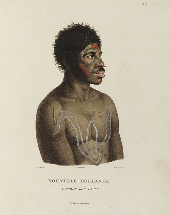
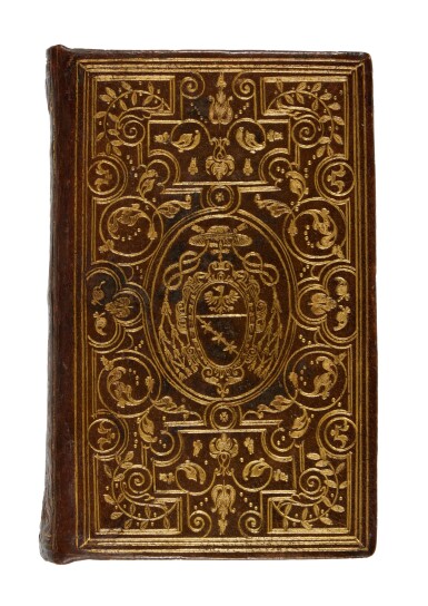
FRANÇOIS PÉRON (1775-1810) AND LOUIS CLAUDE DE SAULCES DE FREYCINET (1779-1842) Voyage de Découvertes aux Terres Australes, exécuté par ordre de Sa Majesté l'empereur et roi, sur les corvettes le Géographie, le Naturaliste, et la goëlette le Casuarina, 1800, 1801, 1802, 1803 et 1804; Rédigé par M.F. Péron. Tome Premier [- Tome Second continué par M. Louis Freycinet]. Paris: Imprimerie Impériale [vol. I] and Imprimerie Royal [vol. II], 1807-1816. 2 volumes, 4° (281 x 213mm). Engraved portrait, 2 folding tables, 2 general half-titles and vol. I half-title, errata leaf. With the very rare 4-page Prospectus for vol. II bound at the end of vol. I. Contemporary French tree calf gilt, boards with borders of gilt foliate rolls within single rules, spines gilt in compartments, gilt morocco lettering-pieces in 2, yellow sprinkled edges (extremities lightly rubbed, slight cracking on joints). Atlas par MM. Lesueur et Petit [- par Mr. L. Freycinet] . [Paris]: Langlois, [1807]-1811. 2 parts in one volume, 2° (340 x 258mm). Part I: engraved title, contents leaves and 40 engraved plates including the folding panoramas of Sydney and Timor, 24 hand-coloured. (Some off-setting onto tissues.) Part II: engraved title, contents leaves and 14 engraved maps, 2 folding, including the 'Carte Générale de la Nouvelle-Hollande' which is also listed as plate 1, part I. (Folding maps with 3 tears at folds.) Contemporary tree-calf backed marbled boards, spine gilt in compartments, gilt morocco lettering-pieces in 2, near-uniform with the text volumes (a little rubbed, spine-ends chipped with small losses). Partie Navigation et Géographie, Rédigée par Louis Freycinet. Atlas. Paris: [s.n.], 1812. 2° (547 x 417mm). Engraved title, contents leaf and 32 engraved maps, 25 double-page. (Title verso, general map, 3 final maps and most margins spotted, small stain to one map.) Modern crimson half morocco gilt over marbled boards, spine gilt in compartments, lettered in one. RARE FIRST EDITION OF THE COMPLETE PARTIE HISTORIQUE AND ATLAS TO THE PARTIE NAVIGATION ET GÉOGRAPHIQUE of Baudin's expedition to Australia, the great French voyage which might have matched Flinders' achievements. The expedition was commanded by Nicholas Baudin for the Institute of France in 1800 and charged with making a full and minute examination of the Australian coasts, particularly the southern coast 'where there is supposed to be a strait communicating with the Gulf of Carpentaria and which consequently would divide New Holland into two large and almost equal islands'. It did not succeed in the Institute's ambitious aims under Baudin's lax leadership, and Freycinet's maps and charts ignore previous British discoveries, depicting the whole of the south coast as 'Terre Napola©on'. Nevertheless, Baudin discovered some two hundred miles of coast between Encounter Bay and Cape Banks, thus completing the discovery of the unknown south coast begun by Flinders and Grant, and also reported in detail on Tasmania, Western Australia, and Sydney. Of further importance was the very large and excellent zoological collection prepared by Péron, naturalist on the voyage. The Atlas plates to the historical narrative are by expedition artists Nicholas Petit and Charles Leseueur, and Petit's depictions of the aborigines are said to be 'fairly true representations of his subjects'. Vol. II of the historical narrative was completed by Freycinet after Péron's early death. To accompany the hydrographic atlas he also published a quarto volume of technical text which is not present with this set. Of the 32 superbly engraved maps in this atlas, the large general map of Australia is the same as that in part II of the atlas to the narrative -- both with a fine illustrated cartouche. Ferguson 449, 536; Hill 1329. (4)
FRANÇOIS PÉRON (1775-1810) AND LOUIS CLAUDE DE SAULCES DE FREYCINET (1779-1842) Voyage de Découvertes aux Terres Australes, exécuté par ordre de Sa Majesté l'empereur et roi, sur les corvettes le Géographie, le Naturaliste, et la goëlette le Casuarina, 1800, 1801, 1802, 1803 et 1804; Rédigé par M.F. Péron. Tome Premier [- Tome Second continué par M. Louis Freycinet]. Paris: Imprimerie Impériale [vol. I] and Imprimerie Royal [vol. II], 1807-1816. 2 volumes, 4° (281 x 213mm). Engraved portrait, 2 folding tables, 2 general half-titles and vol. I half-title, errata leaf. With the very rare 4-page Prospectus for vol. II bound at the end of vol. I. Contemporary French tree calf gilt, boards with borders of gilt foliate rolls within single rules, spines gilt in compartments, gilt morocco lettering-pieces in 2, yellow sprinkled edges (extremities lightly rubbed, slight cracking on joints). Atlas par MM. Lesueur et Petit [- par Mr. L. Freycinet] . [Paris]: Langlois, [1807]-1811. 2 parts in one volume, 2° (340 x 258mm). Part I: engraved title, contents leaves and 40 engraved plates including the folding panoramas of Sydney and Timor, 24 hand-coloured. (Some off-setting onto tissues.) Part II: engraved title, contents leaves and 14 engraved maps, 2 folding, including the 'Carte Générale de la Nouvelle-Hollande' which is also listed as plate 1, part I. (Folding maps with 3 tears at folds.) Contemporary tree-calf backed marbled boards, spine gilt in compartments, gilt morocco lettering-pieces in 2, near-uniform with the text volumes (a little rubbed, spine-ends chipped with small losses). Partie Navigation et Géographie, Rédigée par Louis Freycinet. Atlas. Paris: [s.n.], 1812. 2° (547 x 417mm). Engraved title, contents leaf and 32 engraved maps, 25 double-page. (Title verso, general map, 3 final maps and most margins spotted, small stain to one map.) Modern crimson half morocco gilt over marbled boards, spine gilt in compartments, lettered in one. RARE FIRST EDITION OF THE COMPLETE PARTIE HISTORIQUE AND ATLAS TO THE PARTIE NAVIGATION ET GÉOGRAPHIQUE of Baudin's expedition to Australia, the great French voyage which might have matched Flinders' achievements. The expedition was commanded by Nicholas Baudin for the Institute of France in 1800 and charged with making a full and minute examination of the Australian coasts, particularly the southern coast 'where there is supposed to be a strait communicating with the Gulf of Carpentaria and which consequently would divide New Holland into two large and almost equal islands'. It did not succeed in the Institute's ambitious aims under Baudin's lax leadership, and Freycinet's maps and charts ignore previous British discoveries, depicting the whole of the south coast as 'Terre Napola©on'. Nevertheless, Baudin discovered some two hundred miles of coast between Encounter Bay and Cape Banks, thus completing the discovery of the unknown south coast begun by Flinders and Grant, and also reported in detail on Tasmania, Western Australia, and Sydney. Of further importance was the very large and excellent zoological collection prepared by Péron, naturalist on the voyage. The Atlas plates to the historical narrative are by expedition artists Nicholas Petit and Charles Leseueur, and Petit's depictions of the aborigines are said to be 'fairly true representations of his subjects'. Vol. II of the historical narrative was completed by Freycinet after Péron's early death. To accompany the hydrographic atlas he also published a quarto volume of technical text which is not present with this set. Of the 32 superbly engraved maps in this atlas, the large general map of Australia is the same as that in part II of the atlas to the narrative -- both with a fine illustrated cartouche. Ferguson 449, 536; Hill 1329. (4)
.jpg)


.jpg)
.jpg)
.jpg)


Testen Sie LotSearch und seine Premium-Features 7 Tage - ohne Kosten!
Lassen Sie sich automatisch über neue Objekte in kommenden Auktionen benachrichtigen.
Suchauftrag anlegen