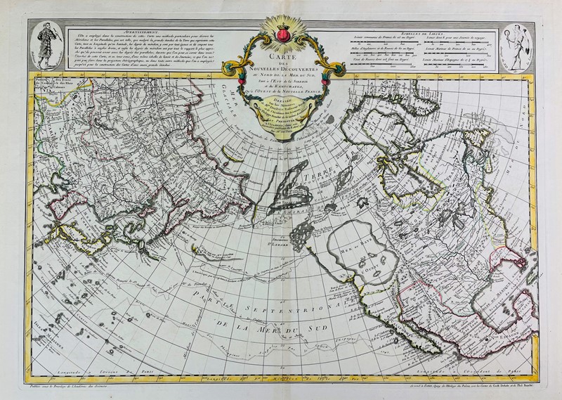
Carte des Nouvelles Découvertes au Nord de la Mer du Sud, Tant à 'Est de la Siberie et du Kamtchatka, ou à l'Ouest de la Nouvelle France... Author: De l'Isle, Joseph Nicolas Place: Venise Publisher: Chez François Santini Date: [1776] Description: Copper-engraved map, 44.3x65 cm (17½x25½ Santini's republication of Joseph Nicolas De l'Isle's important and influential map centered where the American and Asian continents meet, and including the whole of North America and much of Asia. Wagner describes 1750 first issue by De l'Isle as as "Engraved map...on a spherical projection, purporting to have presented by Delisle to the Academie des Sciences, April 8, 1750, when Delisle read his memoir. This map may not have been issued until June, 1752, with Delisle's Explication of the same map. At the top is an explanation of the projection used. The track of Fonte is laid down along the coast, omitted from the next issue..." The map has a series of rivers and lakes allowing the possibility of a water passage between the Pacific and Atlantic Ocean. There is the "Mer our Baye de l'Ouest" taking up a vast portion of the Northwest. There are also many other features of great significance, including the routes of exploration of Tchirikow and De l'Isle in 1741; Bering's exploration of Kamtchatka and beyond in 1732; the track of de Frondat's voyage of 1709; and the route of the Manilla "Galions" in 1743. (Schwartz & Ehrenberg p. 161, pl. 94; Tooley America p.35, map 103; Wagner, NW Coast, 566). Lot Amendments Condition: Dark discoloration, likely a mold stain, some creasing, paper weak in places; good, an important map deserving of restoration. Lots sold without reserve are sold "as is" and are not returnable under any circumstances. The minimum shipping and handling per invoice is $25 for shipments to the US and $40 for shipments sent outside the US Please consider this when determining your bid amounts Item number: 343839
Carte des Nouvelles Découvertes au Nord de la Mer du Sud, Tant à 'Est de la Siberie et du Kamtchatka, ou à l'Ouest de la Nouvelle France... Author: De l'Isle, Joseph Nicolas Place: Venise Publisher: Chez François Santini Date: [1776] Description: Copper-engraved map, 44.3x65 cm (17½x25½ Santini's republication of Joseph Nicolas De l'Isle's important and influential map centered where the American and Asian continents meet, and including the whole of North America and much of Asia. Wagner describes 1750 first issue by De l'Isle as as "Engraved map...on a spherical projection, purporting to have presented by Delisle to the Academie des Sciences, April 8, 1750, when Delisle read his memoir. This map may not have been issued until June, 1752, with Delisle's Explication of the same map. At the top is an explanation of the projection used. The track of Fonte is laid down along the coast, omitted from the next issue..." The map has a series of rivers and lakes allowing the possibility of a water passage between the Pacific and Atlantic Ocean. There is the "Mer our Baye de l'Ouest" taking up a vast portion of the Northwest. There are also many other features of great significance, including the routes of exploration of Tchirikow and De l'Isle in 1741; Bering's exploration of Kamtchatka and beyond in 1732; the track of de Frondat's voyage of 1709; and the route of the Manilla "Galions" in 1743. (Schwartz & Ehrenberg p. 161, pl. 94; Tooley America p.35, map 103; Wagner, NW Coast, 566). Lot Amendments Condition: Dark discoloration, likely a mold stain, some creasing, paper weak in places; good, an important map deserving of restoration. Lots sold without reserve are sold "as is" and are not returnable under any circumstances. The minimum shipping and handling per invoice is $25 for shipments to the US and $40 for shipments sent outside the US Please consider this when determining your bid amounts Item number: 343839
.jpg)


Testen Sie LotSearch und seine Premium-Features 7 Tage - ohne Kosten!
Lassen Sie sich automatisch über neue Objekte in kommenden Auktionen benachrichtigen.
Suchauftrag anlegen