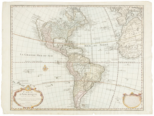
Title: Carte d'Amérique, Dressée pour Instruction, Par Guil. Delisle et Phil. Buache, Premiers Geographes de l'Academie des Sciences. Nouvellement Revue, Augmentée et Assujetie aux Nles. Observations Astronomiques de Mrs. de l'Academie des Sciences. Par Dezauche Géographe, Successeur des Srs. Delisle et Phil. Buache Author: Dezauche, J.A. Place: Paris Publisher: Chez l'Auteur Date: 1800 Description: Copper-engraved map, hand-colored in outline; uncolored cartouche. 47x59 cm. (18½x23¼"). Dezauche's revision of the De l'Isle/Buache map of North and South America which first came out in 1722. This 1800 issue is virtually the same as the first Dezauche version, published in 1785, except for alterations on the title, cartouche and watermark to reflect the political changes in France in that time of turmoil, plus a few minor changes in the plate. About that 1785 issue, Tooley writes, "The map is now redrawn and re-engraved with the inset continuation of the N.W. coast corrected according to Capt. Cook's discoveries. California is noticeably different and the names along the west coast are considerably altered, e.g. Monterey is now shown at the head of R. du Carmel. To the north appears entrée d'Agular, entrée du Roi Georges and Fousang des Chinois. The Great Lakes are now more accurately drawn and the huge L. Bourbon compressed. Port Royale, Halifax, Plaisance (Newfoundland) Portsmouth, Philadelphia &c. shown. The Papal line of Demarcation and the Isles de Quiros are erased and the title cartouche has been enlarged. Easter Island now lettered `I. de Pasques vue par Davis.'" In this 1790 issue, the royal arms have been erased from the cartouche and replaced by ribbons, the King's name is removed from the title and De l'Isle and Buache referred to as First Geographers to the Academy of Science, rather than the King; the watermark "B [heart] R/ F" on one side, a wreath-like circle on the other. Tooley p.16, No. 15. Lot Amendments Condition: A few slight creases; near fine to fine. Item number: 209283
Title: Carte d'Amérique, Dressée pour Instruction, Par Guil. Delisle et Phil. Buache, Premiers Geographes de l'Academie des Sciences. Nouvellement Revue, Augmentée et Assujetie aux Nles. Observations Astronomiques de Mrs. de l'Academie des Sciences. Par Dezauche Géographe, Successeur des Srs. Delisle et Phil. Buache Author: Dezauche, J.A. Place: Paris Publisher: Chez l'Auteur Date: 1800 Description: Copper-engraved map, hand-colored in outline; uncolored cartouche. 47x59 cm. (18½x23¼"). Dezauche's revision of the De l'Isle/Buache map of North and South America which first came out in 1722. This 1800 issue is virtually the same as the first Dezauche version, published in 1785, except for alterations on the title, cartouche and watermark to reflect the political changes in France in that time of turmoil, plus a few minor changes in the plate. About that 1785 issue, Tooley writes, "The map is now redrawn and re-engraved with the inset continuation of the N.W. coast corrected according to Capt. Cook's discoveries. California is noticeably different and the names along the west coast are considerably altered, e.g. Monterey is now shown at the head of R. du Carmel. To the north appears entrée d'Agular, entrée du Roi Georges and Fousang des Chinois. The Great Lakes are now more accurately drawn and the huge L. Bourbon compressed. Port Royale, Halifax, Plaisance (Newfoundland) Portsmouth, Philadelphia &c. shown. The Papal line of Demarcation and the Isles de Quiros are erased and the title cartouche has been enlarged. Easter Island now lettered `I. de Pasques vue par Davis.'" In this 1790 issue, the royal arms have been erased from the cartouche and replaced by ribbons, the King's name is removed from the title and De l'Isle and Buache referred to as First Geographers to the Academy of Science, rather than the King; the watermark "B [heart] R/ F" on one side, a wreath-like circle on the other. Tooley p.16, No. 15. Lot Amendments Condition: A few slight creases; near fine to fine. Item number: 209283


Try LotSearch and its premium features for 7 days - without any costs!
Be notified automatically about new items in upcoming auctions.
Create an alert