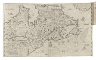
Carte geographique de la Novelle franse en son vray mondia. Paris, 1612. Collée sur papier fort. Déchirure à droite de la carte sur 9 cm restaurée. Marge inférieure droite manquante.- Laid down on strong paper. Repair of tear 9 cm into engraved area in the right hand part of the map. The lower part of the right hand margin is missing, not affecting the engraved area. 255 x 340 mm. Premier état de la carte publiée par Champlain dans "Les Voyages du Sieur de Champlain" fin 1612 ou début 1613. Elle figure la découverte de la baie d'Hudson par Henry Hudson - First state of the map published by Champlain in "Les Voyages du Sieur de Champlain" in either late 1612 or early 1613. The discoveries of Hudson have been incorporated and provide a remarkably accurate interpretation of the geography of the region. The map related the numerous voyages of Champlain to 1611, and the English further to the north. Most particularly recorded is the discovery by Henry Hudson of the bay named after him. It is noted, with the legend noticeably in English, "the bay wher hudson did winter". - Kershaw, Early printed maps of Canada, 61; Burden, The Mapping of North America, 161.
Carte geographique de la Novelle franse en son vray mondia. Paris, 1612. Collée sur papier fort. Déchirure à droite de la carte sur 9 cm restaurée. Marge inférieure droite manquante.- Laid down on strong paper. Repair of tear 9 cm into engraved area in the right hand part of the map. The lower part of the right hand margin is missing, not affecting the engraved area. 255 x 340 mm. Premier état de la carte publiée par Champlain dans "Les Voyages du Sieur de Champlain" fin 1612 ou début 1613. Elle figure la découverte de la baie d'Hudson par Henry Hudson - First state of the map published by Champlain in "Les Voyages du Sieur de Champlain" in either late 1612 or early 1613. The discoveries of Hudson have been incorporated and provide a remarkably accurate interpretation of the geography of the region. The map related the numerous voyages of Champlain to 1611, and the English further to the north. Most particularly recorded is the discovery by Henry Hudson of the bay named after him. It is noted, with the legend noticeably in English, "the bay wher hudson did winter". - Kershaw, Early printed maps of Canada, 61; Burden, The Mapping of North America, 161.
.jpg)

.jpg)


.jpg)

Try LotSearch and its premium features for 7 days - without any costs!
Be notified automatically about new items in upcoming auctions.
Create an alert