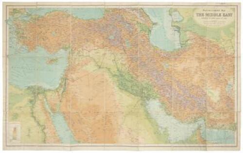
(Middle East) Bartholomew's Map of the Middle East: Coloured to show height of land Place Published: Edinburgh Publisher: Published at the Edinburgh Geographical Institute by John Bartholomew & Son Date Published: c.1922 Description: Color map. 53.5x88.2 cm (21x34¾") plus margins, folding to 21x13 cm (8¼x5¼"), with printed paper cover panels. Topographical and political map of the Nile and Bosphorus in the west to the border of Afghanistan in the east. The panel title reads "Bartholomew's World survey series... The Middle East, Turkey, Syria, Mesopotamia, Persia, etc." Label of Edward Stanford Ltd. partially obscuring imprint on panel. OCLC locates eight copies. Condition: A bit of rippling to the map, very good. Item#: 353509a Headline: Middle East following WWI
(Middle East) Bartholomew's Map of the Middle East: Coloured to show height of land Place Published: Edinburgh Publisher: Published at the Edinburgh Geographical Institute by John Bartholomew & Son Date Published: c.1922 Description: Color map. 53.5x88.2 cm (21x34¾") plus margins, folding to 21x13 cm (8¼x5¼"), with printed paper cover panels. Topographical and political map of the Nile and Bosphorus in the west to the border of Afghanistan in the east. The panel title reads "Bartholomew's World survey series... The Middle East, Turkey, Syria, Mesopotamia, Persia, etc." Label of Edward Stanford Ltd. partially obscuring imprint on panel. OCLC locates eight copies. Condition: A bit of rippling to the map, very good. Item#: 353509a Headline: Middle East following WWI



Testen Sie LotSearch und seine Premium-Features 7 Tage - ohne Kosten!
Lassen Sie sich automatisch über neue Objekte in kommenden Auktionen benachrichtigen.
Suchauftrag anlegen