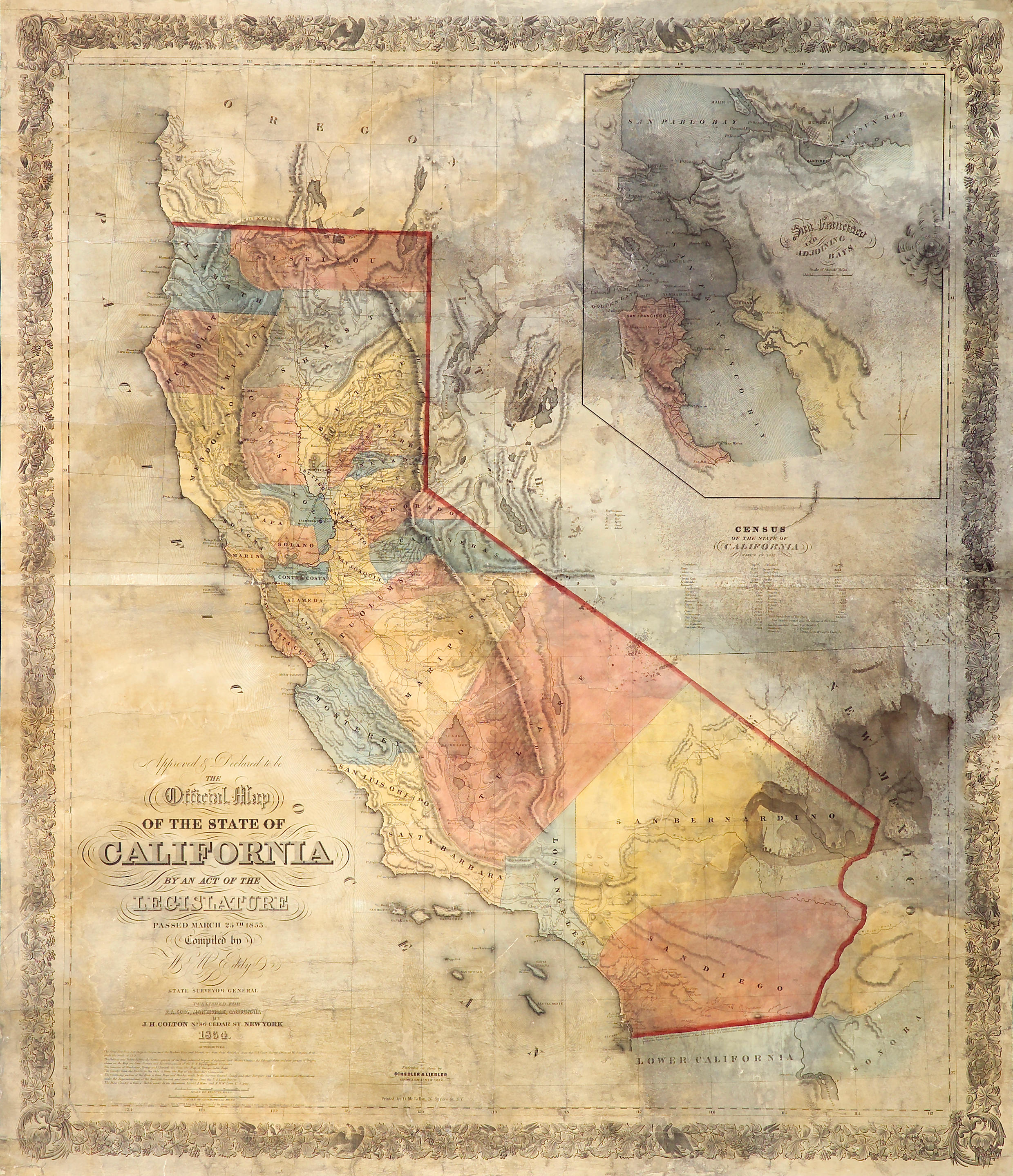
Title: Approved & Declared to be The Official Map of the State of California by an Act of the Legislature Passed March 25th 1853. Compiled by W.M. Eddy, State Surveyor General. Published for R.A. Eddy, Marysville, California... Author: Eddy, William Marston Place: New York Publisher: J.H. Colton Date: 1854 Description: Lithographed map, hand-colored. 126.4x97.8 cm. (49x38½") plus ornamental border, once folding into original blindstamped leather folder lettered in gilt, 15.5x10.5 cm. (6¼x4"); now backed with tissue and flattened, folder present, with Colton advertisement on inside of front cover. Rare example of this seminal and important map of California, inscribed and signed by Eddy on the inside of the front cover, on the Colton advertisement, "Genl Hitchcock from Wm M Ed[dy ]." See below for note about the rarity of this inscription. This was the first official map of the state of California, fixing the borders that are, for the most part, known today. The basic boundaries were laid down at the State Constitutional Convention of 1849, and one of the first acts of the State Surveyor General was to call for the State Surveyor General to prepare a map of the state. In early 1852, William Eddy, the second Surveyor General, after some wrangling with the legislature over his budget, conducted a survey of the central part of the state, with his reduced budget necessitating that the remaining topographical information be supplied by the United States Coast Survey and other sources. The map was completed and accepted in manuscript form in March of 1853. Warren Heckrotte notes that “Eddy’s map is large, in full color, and is splendid in appearance.” It advanced the mapping of California in significant ways beyond the setting of its boundaries. It was the first map to show the eastern slope of the Sierra Nevada in its approximately correct location. Additionally, it contains a large and generally accurate inset map of San Francisco Bay. Heckrotte states that "Eddy's map was a good map, the best up to this time, but nevertheless it had flaws. Because it was the 'Official Map' it was judged harshly, one critic calling it 'shameful'... The most glaring error is the position of the diagonal portion of the boundary which runs too far to the east... an error which arose from a map of the Topographical Engineers that Eddy used... The State Legislature accepted the finished map, but with the caveat that it would not be bound by the representation of the eastern border..." It was soon to be superseded by the map of George Goddard, and in 1873 the California Geological Survey produced a map based on a trigonometric survey of the whole state, which required a full decade of work. The inscription by William Eddy in the folder of the present copy is rare and significant, providing important information on the earliest availability of the map. According to Wheat, Eddy died in March, 1854. Wheat states that map was not yet ready in March 1854 but does not give a reason. However, Eddy as Surveyor General states in his report dated Dec. 15, 1853, that he has received a few copies of the map and more were soon expected. This then, is one of those few copies. The inscribed folder has been rebacked, and the last two letters of Eddy's name eradicated, but the signature does match the signature on Eddy's Surveyor General's Report for 1852, which is offered in the book section of this catalogue. . Provenance: Sotheby's NY, 4/28/82 References: Cohen, Mapping the West, pp.167-69; Heckrotte, California 49, Map 34; Streeter Sale 2761; Wheat, Maps of the California Gold Region, 257; Wheat Transmississippi 257; Wheat 25 California Maps 19; Streeter 2761; Rowell p 9; Phillips, A Descriptive List of Maps of California and San Francisco up to 1865, 142. Lot Amendments Condition: Folder rebacked, scuffed at edges; map expertly rebacked with tissue and restored, repairing splits at folds and a few minor chips, slight darkening at some
Title: Approved & Declared to be The Official Map of the State of California by an Act of the Legislature Passed March 25th 1853. Compiled by W.M. Eddy, State Surveyor General. Published for R.A. Eddy, Marysville, California... Author: Eddy, William Marston Place: New York Publisher: J.H. Colton Date: 1854 Description: Lithographed map, hand-colored. 126.4x97.8 cm. (49x38½") plus ornamental border, once folding into original blindstamped leather folder lettered in gilt, 15.5x10.5 cm. (6¼x4"); now backed with tissue and flattened, folder present, with Colton advertisement on inside of front cover. Rare example of this seminal and important map of California, inscribed and signed by Eddy on the inside of the front cover, on the Colton advertisement, "Genl Hitchcock from Wm M Ed[dy ]." See below for note about the rarity of this inscription. This was the first official map of the state of California, fixing the borders that are, for the most part, known today. The basic boundaries were laid down at the State Constitutional Convention of 1849, and one of the first acts of the State Surveyor General was to call for the State Surveyor General to prepare a map of the state. In early 1852, William Eddy, the second Surveyor General, after some wrangling with the legislature over his budget, conducted a survey of the central part of the state, with his reduced budget necessitating that the remaining topographical information be supplied by the United States Coast Survey and other sources. The map was completed and accepted in manuscript form in March of 1853. Warren Heckrotte notes that “Eddy’s map is large, in full color, and is splendid in appearance.” It advanced the mapping of California in significant ways beyond the setting of its boundaries. It was the first map to show the eastern slope of the Sierra Nevada in its approximately correct location. Additionally, it contains a large and generally accurate inset map of San Francisco Bay. Heckrotte states that "Eddy's map was a good map, the best up to this time, but nevertheless it had flaws. Because it was the 'Official Map' it was judged harshly, one critic calling it 'shameful'... The most glaring error is the position of the diagonal portion of the boundary which runs too far to the east... an error which arose from a map of the Topographical Engineers that Eddy used... The State Legislature accepted the finished map, but with the caveat that it would not be bound by the representation of the eastern border..." It was soon to be superseded by the map of George Goddard, and in 1873 the California Geological Survey produced a map based on a trigonometric survey of the whole state, which required a full decade of work. The inscription by William Eddy in the folder of the present copy is rare and significant, providing important information on the earliest availability of the map. According to Wheat, Eddy died in March, 1854. Wheat states that map was not yet ready in March 1854 but does not give a reason. However, Eddy as Surveyor General states in his report dated Dec. 15, 1853, that he has received a few copies of the map and more were soon expected. This then, is one of those few copies. The inscribed folder has been rebacked, and the last two letters of Eddy's name eradicated, but the signature does match the signature on Eddy's Surveyor General's Report for 1852, which is offered in the book section of this catalogue. . Provenance: Sotheby's NY, 4/28/82 References: Cohen, Mapping the West, pp.167-69; Heckrotte, California 49, Map 34; Streeter Sale 2761; Wheat, Maps of the California Gold Region, 257; Wheat Transmississippi 257; Wheat 25 California Maps 19; Streeter 2761; Rowell p 9; Phillips, A Descriptive List of Maps of California and San Francisco up to 1865, 142. Lot Amendments Condition: Folder rebacked, scuffed at edges; map expertly rebacked with tissue and restored, repairing splits at folds and a few minor chips, slight darkening at some








Testen Sie LotSearch und seine Premium-Features 7 Tage - ohne Kosten!
Lassen Sie sich automatisch über neue Objekte in kommenden Auktionen benachrichtigen.
Suchauftrag anlegen