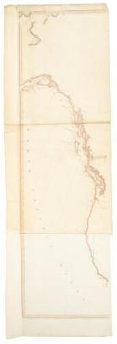
Title: A Map Exhibiting all the New Discoveries in the Interior Parts of North America Inscribed by Permission to the Honorable Governor and Company of Adventurers of England Trading into Hudsons Bay in testimony of their liberal Communications to their most Obedient and very Humble Servant A. Arrowsmith Author: Arrowsmith, Aaron Place: London Publisher: Date: 1796 Description: Engraved map on three sheets, outline color. Right-hand sheet: 91x56.3 cm (35¾x22¼"); center sheet: 91x56 cm (35¾x22"); left-hand sheet: 91x56.3 cm (35¾x22¼"). The third issue of Aaron Arrowsmith's important and oft-updated map, and the second 1796 issue. This issue is especially important for the addition of information from the expedition of George Vancouver, with much added detail in the Pacific Northwest. The map concentrates on Canada and points north, with the west coast charted from Cape Mendocino to Bering's Strait. The center sheet bears the title, and there is a printed flap about 10x9", containing map details, attached beneath the title. OCLC/WorldCat lists only six examples of 1796 issues of the map, with no differentiation on whether they were the first or second 1796 issues - only one, at the British Library, makes mention of the printed flap, which shows the geography of the Coppermine River, and North-East of the Great Slave Lake. Carl Wheat, in his description of this map, notes that he had never seen the 1795 first issue, such is its great rarity (OCLC lists only one copy, in German), and he quotes Stevens, Son & Stiles as stating that the 1795 issue was "so rare that we ourselves have never possessed a copy." Wheat goes on to quote the firm's description of Aaron Arrowsmith, that he was the "head of the well-known family of Cartographers, published a number of large size maps which to this day retain a well merited reputation for their accuracy, distinctness and fine engraving. He understood the projection of maps so thoroughly that he was enabled to utilise, in a way peculiarly his own, the vast store of information supplied him by Dalrymple, the Hudson's Bay Co., the East India Co., and others. Arrowsmith lived during a period when new discoveries were being made all over the world, and his maps were never allowed to become out of date..." For the best description of early issues of this map, see Warren Heckrotte's article in The Map Collector, June 1987. Further Notes from the Files of Warren Heckrotte Full title: Arrowsmith, Aaron A Map Exhibiting all the New Discoveries in the Interior Parts of North America Inscribed by Permission to the Honorable Governor and Company of Adventurers of England Trading into Hudsons Bay In testimony of their liberal Communications to their most Obedient and very Humble Servant A. Arrowsmith | Charles Street, Soho January 1st 1795 Additions to 1796 | Scale of Geometrical Miles [linear scale] Scale of British Miles nearly 69 1/4 to a degree. |[in lower margin:] London, Published as the Act directs Janry. 1st. 1795 by A. Arrowsmith, Charles Street, Soho Square Sheets are numbered on verso, 46,47,48. Scale is one inch equals 60 geometrical miles. Watermark: "Russell 1798" on each sheet. Projection: simple conic. The map extends south to 42° and as far west to include Fox Islands. Cook's tracks are shown. The results of Vancouver's explorations on the north west coast are now shown. Provenance: Old Print Shop, 1/73 References: W-TW 231. Tooley, MCC, 68, #134. Heckrotte, TMC, 6/87 where the best description of early issues of this map is given. Lot Amendments Condition: Some mostly marginal dampstaining, a few tears in western sheet repaired, splitting at centerfolds of the other sheets; overall very good. Item number: 267426
Title: A Map Exhibiting all the New Discoveries in the Interior Parts of North America Inscribed by Permission to the Honorable Governor and Company of Adventurers of England Trading into Hudsons Bay in testimony of their liberal Communications to their most Obedient and very Humble Servant A. Arrowsmith Author: Arrowsmith, Aaron Place: London Publisher: Date: 1796 Description: Engraved map on three sheets, outline color. Right-hand sheet: 91x56.3 cm (35¾x22¼"); center sheet: 91x56 cm (35¾x22"); left-hand sheet: 91x56.3 cm (35¾x22¼"). The third issue of Aaron Arrowsmith's important and oft-updated map, and the second 1796 issue. This issue is especially important for the addition of information from the expedition of George Vancouver, with much added detail in the Pacific Northwest. The map concentrates on Canada and points north, with the west coast charted from Cape Mendocino to Bering's Strait. The center sheet bears the title, and there is a printed flap about 10x9", containing map details, attached beneath the title. OCLC/WorldCat lists only six examples of 1796 issues of the map, with no differentiation on whether they were the first or second 1796 issues - only one, at the British Library, makes mention of the printed flap, which shows the geography of the Coppermine River, and North-East of the Great Slave Lake. Carl Wheat, in his description of this map, notes that he had never seen the 1795 first issue, such is its great rarity (OCLC lists only one copy, in German), and he quotes Stevens, Son & Stiles as stating that the 1795 issue was "so rare that we ourselves have never possessed a copy." Wheat goes on to quote the firm's description of Aaron Arrowsmith, that he was the "head of the well-known family of Cartographers, published a number of large size maps which to this day retain a well merited reputation for their accuracy, distinctness and fine engraving. He understood the projection of maps so thoroughly that he was enabled to utilise, in a way peculiarly his own, the vast store of information supplied him by Dalrymple, the Hudson's Bay Co., the East India Co., and others. Arrowsmith lived during a period when new discoveries were being made all over the world, and his maps were never allowed to become out of date..." For the best description of early issues of this map, see Warren Heckrotte's article in The Map Collector, June 1987. Further Notes from the Files of Warren Heckrotte Full title: Arrowsmith, Aaron A Map Exhibiting all the New Discoveries in the Interior Parts of North America Inscribed by Permission to the Honorable Governor and Company of Adventurers of England Trading into Hudsons Bay In testimony of their liberal Communications to their most Obedient and very Humble Servant A. Arrowsmith | Charles Street, Soho January 1st 1795 Additions to 1796 | Scale of Geometrical Miles [linear scale] Scale of British Miles nearly 69 1/4 to a degree. |[in lower margin:] London, Published as the Act directs Janry. 1st. 1795 by A. Arrowsmith, Charles Street, Soho Square Sheets are numbered on verso, 46,47,48. Scale is one inch equals 60 geometrical miles. Watermark: "Russell 1798" on each sheet. Projection: simple conic. The map extends south to 42° and as far west to include Fox Islands. Cook's tracks are shown. The results of Vancouver's explorations on the north west coast are now shown. Provenance: Old Print Shop, 1/73 References: W-TW 231. Tooley, MCC, 68, #134. Heckrotte, TMC, 6/87 where the best description of early issues of this map is given. Lot Amendments Condition: Some mostly marginal dampstaining, a few tears in western sheet repaired, splitting at centerfolds of the other sheets; overall very good. Item number: 267426


Testen Sie LotSearch und seine Premium-Features 7 Tage - ohne Kosten!
Lassen Sie sich automatisch über neue Objekte in kommenden Auktionen benachrichtigen.
Suchauftrag anlegen